Old Town San Diego Community Plan
About Old Town San Diego
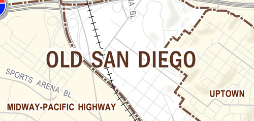
The Old Town San Diego community is the Birthplace of California and of the City of San Diego. The community is 230 acres in size and is located south of Interstate 8 and Mission Valley, east of Interstate 5 and the Midway-Pacific Highway community, and west of the Mission Hills neighborhood of the Uptown community.
Old Town San Diego’s geographic location at the confluence of San Diego Bay and the San Diego River made it ideal for food gathering for early settlers, such as the Native American tribe of the Kumeyaay. The Kumeyaay established the village of Kosaii (also known as Cosoy or Kosa’aay), which was generally located along the San Diego River. This same location was the site of the first permanent European settlement on the Pacific Coast of the United States in 1769, when Don Gaspar de Portola and Padre Junipero Serra established the first mission and Presidio in California as part of the Spanish colonization of Alta California.
In 1822, San Diego became part of the Mexican Republic, following the independence of Mexico from Spain. The Mexican residents of Spanish ancestry in Alta California were known as Californios. By 1827, as many as 30 homes existed around the central plaza in Old Town San Diego. Old Town and the ship landing area, La Playa, were the centers of activity of San Diego. Old Town remained the largest development in San Diego County, as its architecture began to display eastern American influences as trade with foreign ships increased. Following the American takeover of Alta California in 1846, the influx of non-Hispanic people and culture from the United States as well as other countries steadily increased.
Anecdotal tales of gold rush success and a growing confidence that the California territory would not join the slave states began to attract free African-Americans in larger numbers, though primarily to northern counties. In major California cities, newly arrived African Americans served predominantly in service, food, and menial occupations, although Black businessmen and businesswomen were increasingly successful in large urban centers like San Francisco. In San Diego, African-Americans Allen B. Light and his partner Richard Freeman were residents and businessmen in Old Town San Diego in the late 1840s and early 1850s. In 1850, California officially became part of the United States and San Diego County was formally organized. The 1850s saw more settlers begin to arrive in San Diego, including some of the first settlers of Jewish heritage and Chinese immigrants working in the fishing industry.
In 1869, the administrative and economic center of San Diego shifted from Old Town (Old San Diego) to New Town (Downtown). In March 1870, the first plat map of Old Town San Diego was made under the direction of the Board of City Trustees. Old Town’s overall physical structure reflects its history and evolution from a Spanish settlement to an early American town site. It is defined by its unique grid pattern with square blocks and narrow streets, except for San Diego Avenue, which is wider and partially bisects the grid.
Old Town San Diego is in Council District 3.


