Senate Bill 684 Tentative Maps
INFORMATION BULLETIN
414
January 2025
This Information Bulletin addresses the City of San Diego’s ministerial approval process and requirements to implement California Senate Bill 684, which streamlines the process for certain tentative maps for 10 or fewer residential units on qualified lots under 5 acres. It also describes the application requirements for filing a tentative map using provisions that allow a Process One ministerial approval.
Eligibility Criteria
The following are eligibility criteria that determine if a development may utilize the SB 684 tentative map approval process:
- The existing parcel must be zoned for Multiple Dwelling Unit development.
- Find your zone designation: Zoning and Parcel Information Portal (ZAPP)
- Base Zone Designations: Use Regulations Tables in SDMC Chapter 13, Article 1, Divisions 1 through 7
- Planned District Ordinance Zone Designations: Use Regulation Tables in SDMC Chapter 15, Articles 2 through 20
- The existing parcel must be no larger than 5 acres.
- At least 75% of the perimeter of the existing parcel must adjoin, or be separated only by an improved public right-of-way from, parcels that are developed with residential, commercial, public institutional, transit or transportation passenger facility, or retail use, or any combination of those uses.
- The subdivision must result in 10 or fewer parcels.
- The housing development project must be for 10 or fewer residential units.
- The housing development will meet one of the following:
- If the parcel is identified in the City of San Diego Adequate Sites Inventory, it will result in at least as many units as projected for that parcel.
- If the parcel is identified in the City of San Diego Adequate Sites Inventory to accommodate any portion of the City’s share of the regional housing need for very low or low-income households, it will result in at least as many very low or low-income units as projected for that parcel.
- If the parcel is not identified in the City of San Diego Adequate Sites Inventory, it will result in at least as many units as the maximum allowable residential density for the original site.
- New housing units shall be on fee simple ownership lots, part of a common interest development, part of a housing cooperative, or owned by a community land trust.
- The average floor area for new housing units shall not exceed 1,750 square feet.
- The subdivision and new dwelling units shall comply with the requirements for inclusionary affordable housing.
- The housing development shall not require the demolition, alteration, or conversion of any of the following housing types:
- Existing housing subject to a recorded covenant, ordinance, or law that restricts rent to levels affordable to persons and families of low, very low, or extremely low income.
- Existing housing units subject to City of San Diego rent or price control.
- Housing occupied by tenants within the last five years, including housing that has been demolished or that tenants have vacated.
- A parcel on which an owner has exercised the owner’s rights under California Government Code Chapter 12.75 (Ellis Act) to withdraw accommodations from rent or lease within the last 15 years.
- The existing parcel shall not be within the Very High Fire Hazard Severity Zone, as designated by the State.
- The existing parcel shall not contain a hazardous waste site, unless the site has been cleared for residential uses.
- The existing parcel shall not be within a delineated earthquake fault zone, unless the development complies with applicable seismic protection building code standards.
- The existing parcel shall not contain a wetland, any Environmentally Sensitive Lands, or contain area conserved by dedication, a covenant of easement, or conservation easement.
- The existing parcel shall not be located within the Multi-Habitat Planning Area (MHPA) of the Multiple Species Conservation Program (MSCP) Subarea Plan.
- The existing parcel shall not be within Prime farmland or farmland of statewide importance (see California Important Farmland Finder).
- The existing parcel shall not be located within a regulatory floodway as determined by FEMA or a Special Flood Hazard Area, unless the premises have been subject to a Letter of Map Revision prepared by the Federal Emergency Management Agency (FEMA) and issued to the local jurisdiction or the premises meet the FEMA requirements necessary to meet minimum flood plain management criteria of the National Flood Insurance Program.
Projects that require a discretionary development permit may be eligible for the provisions of SB 684 but would still be subject to the discretionary process. Locations within the Coastal Overlay Zone require a Coastal Development Permit for a tentative map and would not be eligible for SB 684.
Tentative Map Process
- A tentative map processed utilizing SB 684 is a Process One ministerial approval. To accommodate the processing of tentative maps utilizing SB 684 provisions, the Development Services Department (DSD) will use the same application, project management, review, and approval or denial framework used for other types of tentative maps, with the following exceptions:
- Tentative maps utilizing SB 684 are not subject to standard findings for a tentative map.
- Tentative maps utilizing SB 684 are not subject to environmental review under the State of California Environmental Quality Act.
- Tentative maps utilizing SB 684 are not subject to public noticing requirements. Posting and mailing requirements applicable for other types of tentative maps are not required. Community Planning Groups do not receive notice.
- Tentative maps utilizing SB 684 do not require a public hearing and may not be appealed.
- SB 684 requires that DSD review and approve or deny the completed tentative map application within 60 days from the date DSD receives it. If the application is denied, DSD will provide written comments with a description of how to remedy the application within 60 days from the date of receiving the complete application. For the purposes of DSD review, each “Project Issues Report” constitutes denial with comments on how to remedy the application.
- Applications for tentative maps utilizing SB 684 should be made in the same way as applications for other tentative maps.
- The tentative map application process and other helpful information are explained here.
- Tentative maps utilizing SB 684 are subject to the same fees as other tentative maps. Information Bulletin 503 provides the required fees for tentative maps.
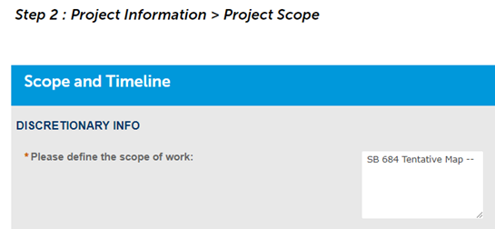
Applicants for tentative maps utilizing SB 684 should clearly state in the “Scope of Work” box in Step 2 of the online application that the scope of work is a “SB 684 Tentative Map”, as shown below. DSD will use the information in the scope of work box to differentiate between SB 684 tentative maps and other tentative maps.
- Step 3 of the Accela online application for a tentative map will request that you upload documents related to public noticing. Since SB 684 applications are not subject to notice requirements, when prompted to provide the “300 Ft Radius Map” and separately the “Owner-Occupant Address Lists,” please instead upload a PDF document that states the following: “This is an application for a Senate Bill 684 Tentative Map. No noticing is required.”
Regulations
Developments shall comply with applicable base zone and overlay zone requirements, except for the following regulations contained in SB 684:
- The minimum parcel size shall be 600 square feet for newly created parcels.
- Developments shall be subject to the floor area ratio limits of the existing parcel’s base zone, with the following exceptions:
- For developments of three to seven dwelling units, the maximum floor area ratio shall be that of the underlying base zone or 1.0, whichever is greater.
- For developments of eight to ten dwelling units, the maximum floor area ratio shall be that of the underlying base zone or 1.25, whichever is greater.
- Setbacks between dwelling units are not required, except as provided by the California Building Code.
- New structures shall comply with the zone's setback provisions, but side and rear yard setbacks from the original lot line may be reduced to 4 feet if the zone requires a greater distance.
- No setback is required for an existing structure, or a new structure constructed in the same location and dimensions as an existing structure.
- Parking for dwelling units required by the San Diego Municipal Code may be reduced to one space per dwelling unit if the Municipal Code requires additional spaces based on location and dwelling unit size.
- Parking spaces may be enclosed or covered.
- Zero off-street parking spaces are required if the project is located in any of the following locations:
- Within one-half mile walking distance of any of the following:
- A transit corridor with fixed route bus service with service intervals no longer than 15 minutes during peak commute hours.
- An existing rail or bus rapid transit station.
- A ferry terminal served by either a bus or rail transit service.
- The intersection of two or more major bus routes with a frequency of service interval of 15 minutes or less during the morning and afternoon peak commute periods.
- Within one block of a car share vehicle.
- Within one-half mile walking distance of any of the following:
Final Map
After approval of a tentative map using SB 684 provisions, a separate application must be filed for a final map.
- This final map must be recorded to create the subdivision.
- There will be conditions of approval for the SB 684 tentative map. These conditions of approval must be met prior to the recordation of the final map.
- The final map application process and other helpful information are explained here.
- Required fees for a final map can be found in Information Bulletin 502.
Building Permit
A separate application must be filed for a building permit. It may be processed concurrently with the Tentative Map, but shall not be issued until the map is approved.
- Any dedication or public improvement that is conditioned by the tentative map shall be recorded or permitted prior to issuance of building permits.
- SB 684 allows for the issuance of building permits prior to the recording of the final map. If the issuance of building permits is requested, a covenant and agreement must be recorded before the permit is issued. This covenant agreement will condition the recordation of the final map prior to final inspection approval or issuance of a certificate of occupancy.
- The building permit application process and other helpful information are explained here.
- Required fees for a building permit can be found in Information Bulletin 501.
- SB 684 requires that DSD review and approve or deny the completed building permit application within 60 days from the date DSD receives it. If the application is denied, DSD will provide written comments with a description of how to remedy the application within 60 days from the date of receiving the complete application. For the purposes of DSD review, each “Project Issues Report” constitutes denial with comments on how to remedy the application.
Previous Versions of this Information Bulletin
This section contains previous versions of this Information Bulletin by the last day they were effective.
- Current Version is July 2024