ADA Right of Way Project

The Accessibility Safety Plan for Individuals with Disabilities in Disadvantaged Communities (Project) is the first phase of a Citywide approach to comprehensively update the public rights-of-way self-evaluation and transition plan. The Project area for the first phase encompasses San Diego neighborhoods generally south of the I-8, which includes most of the City’s historically disadvantaged communities. The Project utilizes a consultant to update data of Project-area pedestrian routes in the public right of way and identify accessibility-related infrastructure and barriers along pedestrian networks.
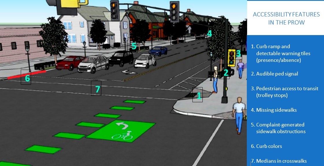
Right-of-way infrastructure that will be inventoried as part of this Project includes audible pedestrian signals at signalized intersections, crosswalks, curb ramps, major barriers on sidewalks, on-street accessible parking, and physical barriers in the public rights-of-way such as street furniture and medians. All identified elements will be mapped using Geographic Information Systems (GIS) with existing evaluation layers such as the Sidewalk Assessment Survey included in evaluations. After the inventory and evaluation is completed, an updated right-of-way transition plan will be developed with a prioritization of barrier removal developed.
While the Project includes a comprehensive assessment of all pedestrian facilities and ADA-relevant assets within the public right of way south of Interstate 8 (I-8), the prioritization of improvements will be guided by a structured, data-informed methodology. This prioritization process is designed to ensure that limited resources are directed where they have the most meaningful impact.
The prioritization approach considers a combination of spatial, social, and functional criteria, including:
Population Density
Areas with higher concentrations of residents, particularly vulnerable populations, are prioritized to enhance safety and accessibility for the greatest number of people.
Connectivity of Facilities
Locations that serve as key links between pedestrian networks and transit infrastructure such as intersections with bus stops, trolley stations, or high-use pathways will be elevated in priority.
Access to Essential Services
Proximity to community resources such as schools, healthcare centers, senior facilities, government offices, grocery stores, and places of worship is a major factor in scoring.
Equity and Environmental Justice
Historically underserved and disadvantaged communities receive additional weighting to align with the City’s equity goals.
Asset Condition and Safety
The physical condition of facilities, ease of construction or improvement, and the presence of safety concerns (e.g., history of pedestrian incidents) are integrated into the evaluation.
Integration with Other Projects
Opportunities to coordinate ADA improvements with planned capital improvement projects or repaving efforts will be factored in to maximize efficiency and reduce disruption.
Other Factors to Be Determined During the Evaluation Process
The project team may identify additional considerations through stakeholder input, community engagement, or emerging patterns in the data that warrant inclusion in the prioritization framework.
A draft prioritization scoring matrix will be presented to the City’s Accessibility Advisory Board (AAB) and shared at community meetings for public input. The matrix will then be refined and applied using GIS analysis tools, allowing the City to visualize and rank projects across neighborhoods. Final prioritization results will be reflected in the updated ADA Transition Plan and used to inform both near and long term investments in accessibility upgrades.
This Project will be a model for safe and accessible access for pedestrians of all abilities. Using the transition plan, the City of San Diego will continue to seek funding to remediate identified deficiencies, incorporate features into bundled capital projects, and create seamless connectivity via walking and rolling to public transit, parks, local retail shops, schools, recreation centers, and places of worship.
About the Project
About Transition Plans
Accessible pedestrian networks improve safety, mobility, and livability for pedestrians of all abilities, and these networks are particularly important for seniors and persons with disabilities. The Americans with Disabilities Act (ADA) of 1990 requires municipalities to complete a self-evaluation and transition plan. A self-evaluation is a comprehensive accessibility review of all programs, activities, and services operated by the public entity; a transition plan includes a list of physical barriers in facilities and the public right-of-way that were identified in the self-evaluation.
History
The City of San Diego adopted its original self-evaluation and transition plan for both the public right-of-way and public facilities in 1996; all major facility barriers in the original plan have been remediated. An update to the facilities transition plan occurred in 2010, and work continues to implement the updated facilities transition plan. The sidewalk-related right-of-way data was updated via the 2015 Sidewalk Inventory and Assessment; that data will be integrated into this grant-funded project. The City continues to fund improvements from the transition plan proactively as part of construction occurring in the right-of-way and by resolving issues reported by individuals with disabilities.
Future
The City of San Diego was awarded Federal Safe Street 4 All (SSFA) grant funding to complete Phase II of the PROW Self Evaluation and Transition Plan, which includes all communities north of Interstate 8. Work is expected to begin in late 2025 and last approximately two years.
Have a question or comment? Please contact us at ADACompliance@sandiego.gov
Project Location
Communities in the Project area include:
- Balboa Park
- Barrio Logan
- College Area
- Downtown San Diego
- Encanto
- Golden Hill
- Mid-City
- Midway-Pacific Highway
- North Park
- Ocean Beach
- Old Town San Diego
- Otay Mesa
- Otay Mesa-Nestor
- Peninsula
- San Ysidro
- Skyline-Paradise Hills
- Southeastern San Diego
- Uptown
Timeline
Phase 1
- Public Outreach (Public Website, Meetings, AAB, Council): 7/2024 – 11/2025
- Data Collection: 7/2024 – 8/2025 (Complete)
Phase 2
- Data Processing (Baseline Development): 7/2024 – 9/2025
- Geographical Information System (GIS) Integration: 7/2024 – 9/2025
Phase 3
- Systematic Review: 7/2024 – 9/2025
- Dashboard Development: 8/2025 – 10/2025
Phase 4
- Draft & Final Project: 10/2025 – 11/2025
Phase 5
- City Staff Training: 1/2026 – 3/2026
Conceptual Layout / Construction Design Plan: 1/2026 – 6/2026
Frequently Asked Questions (FAQ)
What is an ADA Transition Plan?
An ADA Transition Plan is a strategic plan that outlines how a public agency will modify its facilities, services, and programs to comply with the Americans with Disabilities Act (ADA). The plan identifies barriers to accessibility and establishes a schedule for removing these barriers.
Why is the ADA Transition Plan important?
The plan is important because it ensures that individuals with disabilities have equal access to public spaces and services. It reflects the City’s commitment to creating an inclusive and accessible community for all.
How does the ADA Transition Plan impact the community?
By improving accessibility, the ADA Transition Plan benefits not only individuals with disabilities but also the entire community. Equity in pedestrian pathways such as curb ramps, accessible sidewalks, audible pedestrian signals make our public spaces safer and more navigable for all residents, including seniors and families with strollers.
What types of improvements are included in the ADA Transition Plan?
The plan will address a wide range of accessibility issues, including but not limited to sidewalk improvements, curb ramp installations, accessible parking spaces, and audible pedestrian signals at signalized intersections.
Does the transition plan include construction elements?
No, the transition plan does not include construction elements or changes to the PROW. The transition plan identifies what changes need to be made. The Project does include construction deign to 60% of elements and/or areas identified to be priority.
How can I stay updated on the progress of the ADA Transition Project?
You can stay informed by visiting our website regularly, request to subscribe to our email list by sending a request to ADACompliance@sandiego.gov, and follow the City of San Diego Accessibility Board.
I want to report an accessibility issue, how can I do so?
Please file complaints/reports about issues on City property that are related to your disability here: https://getitdone.sandiego.gov/ADACANewReport
How will the City conduct the inventory?
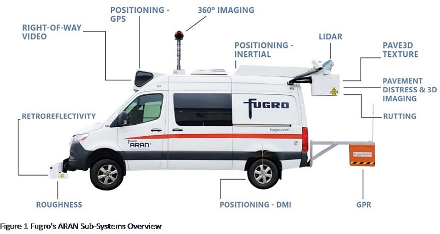
The inventory is collected using a state-of-the-art scanning vehicle. The vehicle collects infrastructure elements including bicycle facilities, curbs, lanes, light poles, median, parking, pavement markings, pavement text/turn lanes, curb ramps, sidewalks, signal equipment, pedestrian push buttons at signalized intersections, signs, utility box.
The infrastructure elements will be collected using photogrammetry. This method obtains accurate measurements, creates maps, and produces 3D models using photographs taken from multiple angles. By analyzing the differences in the images captured from different perspectives, photogrammetry can determine the spatial relationships and dimensions of objects, surfaces, and landscapes. An example of the data collection vehicle is shown below.

Does the City store any photos on the Cloud or a website?
No, the City does not retain photos on the cloud or any website. Photographs are initially captured to identify features within the public right-of-way. Once these features have been digitally mapped, the photographs are no longer needed. They are not linked to any GIS or other digital platforms.
Have a question or comment? Please contact us at ADACompliance@sandiego.gov

